Geotechnical Engineering

geotechnical banner 3

Geotechnical engineering is a branch of civil engineering that focuses on the behavior of earth materials, such as soil, rock, and groundwater, and their interaction with structures built on or in them.  Geotechnical engineers use their knowledge of the physical and mechanical properties of soil and rock to design and construct safe and stable structures, such as buildings, roads, bridges, tunnels, dams, and levees.  Every construction design infrastructure that is supported by foundations, above or below ground such as bridges, dams, plants, slopes, structures, tunnels, etc. uses geotechnical engineering.

Geotechnical Engineering Index

textural soil classification 1atterberg limits relationships 1

The work of a geotechnical engineer typically involves site investigation and analysis, soil and rock testing, foundation design, slope stability analysis, and groundwater assessment.  They use a variety of tools and techniques, such as borehole drilling, geophysical surveys, and laboratory testing, to gather data about the properties of the soil and rock at a construction site.

Geotechnical engineering is an important field because the behavior of earth materials can have a significant impact on the safety and longevity of structures.  By understanding the properties of the soil and rock, geotechnical engineers can design structures that are stable and safe, even in challenging conditions such as earthquake-prone areas or sites with difficult soil conditions.  They also play a key role in environmental engineering, where they study the behavior of soil and groundwater to ensure that contaminants are properly contained and remediated.


Science Branches

Science
Applied Science
Engineering
Civil Engineering

Soil Types (OSHA)

  • Stable Rock  -  Natural soil material that can be excavated with vertical sides and remain intact whole exposed.  It is usually identified by a rock name such as granite or sandstone.  Determining wheather a deposit is of this type may be difficult unless it is known wheather cracks exist and wheather or not the cracks run into or away from the excavation.
  • Type A  -  Cohesive soils with an unconfined compression strength of 1.5 tons per square inch or greater.  Includes clay; sandy clay; silty clay; clay loam; and in some cases, silty clay loam and sandy clay loam.  No soil is Type A if it is fissured; is subject to vibration of any type; has previously been disturbed; is part of a sloped, layered system where the layers dip into the excavation on a slope of four horizontal to one vertical or greater, or has seeping water.
  • Type B  -  Cohesive soils with an unconfined compression strength greater than 0.5 tons per square inch but less than 1.5 tons per square inch and granular cohesionless soils.  Includes angular gravel; silt; silt loam; sandy loam; and unstable rock; previousely disturbed soils unless otherwise classified as Type C; soils that meet the unconfined compressive strength or cementation requirements of Type A soils but are fissured or subject to vibration; dry unstable rock; and layered systems sloping into the trench at a slope less than four horizontal to one vertical.
  • Type C  -  Cohesive soils with an unconfined compression strength of 0.5 tons per square inch or less.  Includes granular soils such as gravel; sand and loam sand; submerged soil; soil fron which water is freely seeping; and submerged rock that is not stable.  Also included in this classification is material in a slope, layered system where the layers dip into the excavation or have a slope of four horizontal to one vertical or greater.
  • Multi Type Soil  -  Layered geological strata.  Whlere soils are configured in layers. where a ayered geological structure exists, the soil must be classified on the basis of the soil classification of the weakest soil layer.  Eacs layer may be classified individually if a more stable layer lies below a less stable layer, where a Type C soil rests on top of stable rock.


Soil Types

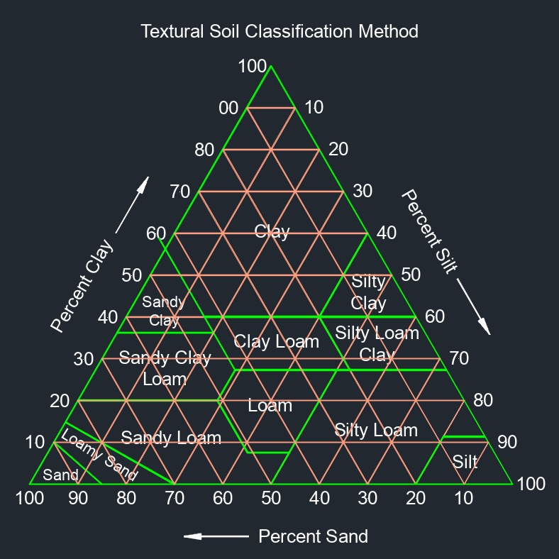
  • Clay  -  Clay soil is composed of tiny particles that are hard and able to become easily compacted.  This compaction makes it difficult to plant or even shovel within the soil.While clay soil can be difficult to work with, it can be beneficial to the growth of certain plants.  It is able to hold onto the roots of plants better and provide a more stable environment than many other types of soil.
  • Clay Loam  -  A fine-textured soil that breaks into clods or lumps that are hard when dry.  When the moist soil is pinched between the thumb and finger, it will form a thin ribbon that will break readily, barely sustaining its own weight.
  • Loam  -  Soil comprised of almost equal amounts of sand and silt and a little less clay.  Of the three components, sand particles are the largest. Sand does not hold onto moisture, but it provides good aeration.  On the opposite end, clay particles are much smaller and easily compact.  That makes clay a great material for building bricks, but not so great for allowing water, air, and plant roots through.
  • Loamy Sand  -  This soil type is normally made up of sand mixed with a majority of silt and clay.  Many people prefer loamy sand soil for their gardening because this type of soil normally allows for good drainage.
  • Silty  -  Silty soils have a distinct silky and soft feeling, typically quite fertile, and have the ideal balance of decent nutrient density without terrible drainage.  Silt soils are usually easy to grow most crops in, although amendments for drainage may be needed for optimal crop performance.  Silty soils don’t compact as easily as clay soils and they are softer and lighter, however, they do lack a robust structure in their soil profile that can be improved through the planting of perennial crops whose root presence holds them together.
  • Silty Clay  -  Silt has larger particles than clay and is mainly inorganic in nature.  A silty clay soil has a higher percentage of clay than silt.
  • Sand  -  This type of soil is easy to cultivate but, since it allows for more drainage than needed, it is important to water it regularly, especially during summer days.  As sandy soils don't allow the water to pool around the roots, they are a good choice for plants that have a tendency to suffer from root decay.
  • Sandy Loam  -  Sandy loam soils have a high concentration of sand that gives them a gritty feel.  In gardens and lawns, sandy loam soils are capable of quickly draining excess water but can not hold significant amounts of water or nutrients for your plants.  Plants grown in this type of soil will require more frequent irrigation and fertilization.


Soil Mechanics (OSHA)

  • Tension Cracks  -  This usually form at a horizontal distance of 0.5 to 0.75 times the depth of the trench, measured from the top of the vertical face of the trench.
  • Sliding or Sluffing  -  May occure as a result of tension cracks.
  • Topping  -  In addition to sliding, tension cracks can cause toppling.  Toppling occurs when the trench's vertical face shears along the tension crack line and topples into the excavation.
  • Subsidence or Bulging  -  An unsupported excavation can create an unbalanced stress in the soil, which, in turn, causes subsidence at the surface and bulging of the vertical face of the trench.  If uncorrected, this condition can cause face failure and entrapment of workers in the trench.
  • Heaving or Squeezing  -  Bottom heaving or squeezing is caused by the downward pressure created by the weight of adjoining soil.  This pressure causes a bulge in the bottom of the cut, as illustrated in the drawing above. Heaving and squeezing can occur even when shoring or shielding has been properly installed.
  • Boiling  -  The evidenced by an upward water flow into the bottom of the cut.  A high water table is one of the causes of boiling. Boiling produces a "quick" condition in the bottom of the cut, and can occure even when shoring or trench boxes are used.
  • Soil Weight  -  Unit weight of soils refers to the weight of one unit of a particular soil.  The weight of soil varies with type and moisture content.  One cubic foot of soil can weigh from 110 pounds to 140 pounds or more, and one cubic meter (35.3 cubic feet) of soil can weigh more than 3,000 pounds.


Atterberg Soil Indexes

  • Atterberg Indexes  -  Describes the boundaries of the states of soil in terms of limits and compares the test values mathmatically.
    • Liquid Index  -  Scaling the natural moisture content of a soil sample to the liquid limit and plastic limit.
    • Plastic Index  -  The range of water content over which the soil remains in the plastic state.
    • Consistancy Index  -  The range of water content to the firmness of the soil.


Atterberg Soil Limits

  • Atterberg Limits  -  The basic measure of the critical water contents of a fine-grained soil.  The water contents where the soil behavior changes are liquid limit, plastic limit, and shrinkage limit.
    • Liquid Limit  -  The minimum water content at which soil just begins to flow.
    • Plastic Limit  -  The water content at which the soil changes from semi-solid state to solid state.
    • Shrinkage Limit  -  The maximum water content at which further reduction in the water content will not cause decrease in volume of soil.


Geotechnical Engineering Standards

ASTM Standards

  • ASTM C1242 - Standard Guide for Selection, Design, and Unstallation of Dimension Stone Attachment Systems
  • ASTM D559 - Standard Test Method for Wetting and Drying Compacted Soil-Cement Mixtures
  • ASTM D560 - Standard Test Method for Freezing and Thawing Compacted Soil-Cement Mixtures
  • ASTM D806 - Standard Test Method for Cement Content of Hardened Soil-Cement Mixtures
  • ASTM D806 - Standard Guide for Selection of Dimension Stone
  • ASTM D2434 - Standard Testing Method for Permeability of Granular Soils (Constant Head)
  • ASTM D2487 - Standard Practice for Classification of Soils for Engineering Purposes (Unified Soil Classification System)
  • ASTM D2488 - Standard Practice for Description and Identification of Soils (Visual-Manual Procedures)
  • ASTM D3282 - Standard Practice for Classification of Soils and Soil-Aggregate Mixtures for Highway Construction Purposes
  • ASTM D3966 - Standard Testing Methods for Deep Foundations Under Lateral Load
  • ASTM D4380 - Standard Test Method for Determining Density of Construction Slurries
  • ASTM D4435 - Standard Test Method for Rock Bolt Anchor Pull Test
  • ASTM D4525 - Standard Test Method for Permeability of Rocks by Flowing Air
  • ASTM D4611 - Standard Test Method for Specific Heat of Rock and Soil
  • ASTM D4829 - Standard Test Method for Expansion Index of Soils
  • ASTM D4945 - Standard Testing Methods for High Strain Dynamic Testing for Deep Foundations
  • ASTM D4992 - Standard Practice for Evaluation of Rock to be Used for Erosion Control
  • ASTM D5718 - Standard Guide for Documenting a Groundwater Flow Model Application
  • ASTM D5882 - Standard Testing Methods for Low Strain Impact Integrity Testing for Deep Foundations
  • ASTM D5889 - Standard Practice for Quality Control of Geosynthetic Clay Layers
  • ASTM D6092 - Standard Practice for Specifying Standard Sizes on Stone for Erosion Control
  • ASTM D6128 - Standard Test Method for Shear Testing of Bulk Solids Using the Jenike Shear Tester
  • ASTM D6285 - Standard Guide for Locating Abandoned Wells
  • ASTM D6393 - Standard Test Method for Bulk Solids Characterization by Carr Indices
  • ASTM D6599 - Standard Practice for Construction of Live Fascines on Slopes
  • ASTM D6683 - Standard Test Method for Measuring Bulk Density Values of Powders and Other Bulk Solids as Function of Compressive Stress
  • ASTM D6773 - Standard Test Method for Bulk Solids Using Schulze Ring Shear Tester
  • ASTM D6825 - Standard Guide for Placement of Riprap Revetments
  • ASTM D6940 - Standard Practice for Measuring Sifting Segregation Tendencies of Bulk Solids
  • ASTM D6941 - Standard Practice for Determining Sediment Pond Skimmer Flow Rate
  • ASTM D7099 - Standard Terminology Related to Frozen Soil and Rock
  • ASTM D7407 - Standard Guide for Determinining the Transmission of Gases through Geomembranes
  • ASTM D7765 - Standard Practice for Use of Foundry Sand in Structural Fill and Embankments
  • ASTM D8326 - Standard Practice for Measuring of the Kinetic Energy of Simulated Rainfall


Geotechnical Abbreviations

  • Field Capacity (FC)
  • Root Depth (RD)


Tags: Abbreviations Nomenclature and Symbols

Geotechnical Engineering Glossary

A         

  • Absorbed Water  -  Water in a soil mass.
  • Active Fault  -  Is likely to have another earthquake sometime in the future.
  • Aftershock  -  Earthquakes that follow the largest shock of an earthquake sequence.
  • Aggregate  -  A mixture of sand and stone with the major component concrete.
  • Air Content  -  The ratio of volume of air to total volume of soil.
  • Aquifer  -  A layer of rock or sediment that holds groundwater within.
  • Alluvium  -  Soil that has been transported to its present location by water.
  • Annual Soil Loss  -  Predicts the average annual soil loss by multiplying the factors listed below togeather.
  • Asphalt Concrete  -  A hot mixture of asphalt cement, rubber, fine and coarse aggregate, and a mineral mixture.
  • Atterberg Limit  -  A set of three specific moisture content thresholds that define the physical properties of fine grained soils such as clay and silt.
  • Available Soil Moisture  -  The difference between the amount of water in the soil at field capacity and the amount at the permanent wilting point.
  • Available Water Holding Capacity  -  This is the maximum amount of water that soil can store to be extracted by the plants.  It is the water held between field capacity and permanent wilting point.  The total available water in the soil root zone for a specific crop is equal to the crop’s rooting depth multiplied by the available water-holding capacity per unit depth of the soil.

B         

  • Basic Rock Types  -  Igneous rock, Metamorphic rock, and Sedimentary rock.
  • Basin  -  The entire area drained by a main stream and its tributaries.
  • Bearing Capacity  -  The maximum average load per unit area of a footing that will not produce failure by rupture of the supporting soil.
  • Bedrock  -  Relatively hard solid rock that commonly underlines softer rocks, or soils.
  • Borrow  -  Material taken from one location to be used in another.
  • Borrow Pit  -  A bank or pit where earth is taken from for use as fill elsewhere.
  • Boulder  -  Fragments greater than 256 mm.
  • Branch  -  Small stream.
  • Brook  -  Small stream.
  • Bulk Density  -  The ratio total weight of soil to the total volume of soil.
  • Bulk Unit Weight  -  The bulk or wet weight of soil per unit volume.
  • Buoyant Unit Weight  -  The unit weight of a submerged object minus saturated weight of the object.

C        

  • Capillart Water  -  Water that is under tension in a soil due to stresses produced by menisci forming in the soil pores as water recedes into the voids from evaporation or is lost other means.
  • Clay  -  Particles ranging in size from 0.002 mm and smaller.
  • Climate  -  Precipitation, temperature and other aspects of climate effect how specific soils are formed.
  • Coarse Aggregate  -  Particles ranging in size greater than 4.75 mm.
  • Coarse Sand  -  Particles ranging in size from 0.50 mm to 1.00 mm.
  • Cobble  -  Rock ranging in size from 65 mm to 256 mm.  Larger than a pebble and smaller than a boulder.
  • Cobblestone  -  Rounded or partially rounded stones used in paving roads and streets.
  • Coefficient of Curvature  -  See Curvature Coefficient
  • Coefficient of Uniformity  -  See Uniformity Coefficient
  • Colluvium  -  Soil that has been transported by gravety.
  • Collapsible Soil  -  Low density soils that have considerable strength when dry of moist.
  • Compaction  -  Is rearranging the particles and reduce the voids and increase the density of the soil.
  • Compressibility  -  Measures the change in volume under external forces for any liquid.
  • Compression  -  Squeezing rocks togeather, causing rocks to fold or fracture.
  • Confined Aquifer  -  Layers of impermeable rock or sediment that prevent water from seeping into the groundwater from above.
  • Confined Stress  -  A deeply buried rock is pushed down by the weight of all the material above.  Since the rock cannot move, it cannot deform.
  • Consistancy Index  -  The range of water content to the firmness of the soil.
  • Consistancy Limit  -  The water content at which the soil changes from one state to another state.
  • Constant Head Permeability  -  A test is to determine the permeability of a sandy soil by the constant head test method.
  • Constrictivity  -  A parameter used to describe transportation processes in porous media.
  • Cone Penetrometer Test  -  Used to determine geotechnical properties of soils.  This test has become internationally one of the most widely used and accepted test methods for determining geotechnical soil properties.  A cone on the end of a series of rods is pushed into the ground at a constant rate and continuous measurements are made of the resistance to penetration of the cone and of a surface sleeve.
  • Creek  -  Small stream.
  • Creep  -  A slow and more or less continuous movement occuring on faults due to ongoing tectonic deformation.
  • Crest  -  Land that stands above or almost above surrounding terrain.
  • Critical Hydraulic Gradient  -  The change in height (pressure) to length between any two points.
  • Crop Rooting Depth  -  Crop rooting depth determines how much soil water can be accessed by the crops.  A shallow-rooted crop has less access to soil water as compared to a deep-rooted crop.  Each crop can potentially develop a greater rooting depth.
  • Crust  -  The outermost layer of the earth ranging from about 6 to 40 miles in thickness worldwide.
  • Curvature Coefficient  -  Classifies a soil as well graded or poorly graded.

D         

  • Darcy"s Law  -  The rate at which a fluid flows through a permeable medium.
  • Darcy Velocity  -  The volumetric flow per unit area of a porous mediun.
  • Deep Percolation  -  Water that drains beyond the plant root zone.
  • Degree of Saturation  -  The ratio of volume of water to the volume of voids.
  • Density  -  The ratio of the amount of matter in an object compared to its volume.
  • Diffusion Coefficient  -  A parameter expressing the transfer rate of a substance by random molecular motion.
  • Diffusion Substance  -  A compound species in a diffusing system. 
  • Discharge Velocity  -  The rate of water through a porous medium per unit of total area perpendicular to the direction of flow.
  • Displacement  -  The difference between the initial reference point position and any later position.
  • Drip Irrigation  -  Drip irrigation systems are designed and operated to keep the soil moisture content at a level above the maximum allowable depletion by applying water very frequently.
  • Dry Bulk Density of Soil  -  The ratio between the total mass of soil and the total volume of soil.
  • Dry Soil  -  Contains only air and voids.
  • Dry Unit Weight  -  The weight of soil to the volume of soil or when the soil voids are filled with air and no water. 
  • Ductile Strain  -  A rock that does not go back to its origional state.  Remaines deformed when strain stops.

E         

  • Earthquake  -  A sudden movement on a fault, and the resulting ground shaking, and radiated seismic energy caused by the slip.
  • Effective Diffusion Coefficient  -  A diffusion coefficient in an absorbing system.
  • Effective Diffusivity in Porous Media  -  The adequate dispersion of gas or liguid through the voids of soil.
  • Effective Saturation  -  See Normalized Water Content
  • Elastic Modulus  -  The ratio of the stress applied to a body or substance to the resulting strain within the elastic limits.
  • Elastic Strain  -  A rock that goes back to its origional state.
  • Emissivity  -  The surface depends on the material effectiveness in emitting energy as thermal radiation and varies between 0.0 and 1.0.
  • Erosion  -  The natural wearing away of the earth's surface by tne loss of material from a solid surface due to relative motion in contact with a fluid that contains solid particles.
  • Erosivity  -  A collection of particles, liquid stream, or a slurry that expresses its tendency to cause erosive wear when forcing against a solid surface under relative motion.

F         

  • Falling Head Permeability  -  A test to determine the permeability of a sandy soil.
  • Falsic  -  Magmas that are rich in silica and aluminum.
  • Fault  -  A rock fracture showing evidence of relative movement.
  • Fault Plane  -  A flat surface along which there is slipage during an earthquake.
  • Field Capacity  -  Relates to the amount of soil moisture or water content held in the soil after excess water has drained away and the rate of downward movement has decreased.  This usually takes place 2–3 days after rain or irrigation in previous soils of uniform structure and texture.
  • Fine Aggregate  -  Particles sand or crushed stone ranging in size less than 9.55 mm.
  • Fine Sand  -  Particles ranging in size from 0.10 mm to 0.25 mm.
  • Footing  -  A structural member used to distribute the loads to the soil in such a way that the load bearing capacity of the soil is not exceded.
  • Foreshock  -  Relatively smaller earthquakes that precede the larger earthquake in a series.
  • Fractured  -  A rock that has broken abruptly into pieces.

G         

  • Glacial Till  -  Soil that has been gouged out of the earth's crust by ice at one location and deposited at another.
  • Gravitational Water  -  Water that is free to move through a saturated soil mass under the influence of gravity.
  • Gravity  -  A force pulling togeather all matter.
  • Gravity Wall  -  A retaining wall that depends upon its own weight for stability.
  • Ground Failure  -  A general term referencing landslides, liquefaction, and lateral spreads.
  • Ground Motion  -  Movement of the earth's surface from earthquakes or explosions.
  • Groundwater  -  Water that has traveled down from the top soil to fills the cracks and openings in the rocks and sand.
  • Gully  -  A channel from errosion during intersmittent and concentrated flow of water during heavy rain.

H        

  • Harmonic Tremor  -  Continuous rhythmic earthquakes that can be detected by seismographs.
  • Head  -  The source of a stream.
  • Headwaters  -  The smallest streams that combine to make a larger stream.
  • Heat Capacity  -  The ratio of heat transferred to raise the temperature of an object.
  • Horizontal Stress  -  Stress acting in a horizontal direction.
  • Hydraulic Conductivity  -  The ease with which a fluid can move through porous spaces or fractures. 
  • Hydraulic Gradient  -  The change in height (pressure) to length between any two points.

I         

  • Igneous Rock  -  Formed from the cooling and solidification of hot liquid magma.
  • Infiltration  -  Water movement in the soil.  Pore spaces in the soil allows water to infiltrate and percolate.
  • Intake Rate  -  Relates to the time required to infiltrate a given quantity of water in a specific soil type.  In general, the intake rate of lighter-textured (sandy) soil is higher than that of heavier textured (clay) soil.  However, sprinkler irrigation with a very high quantity of water can lead to surface runoff even on sandy soils.  The intake rate of the soil under irrigation is affected by many factors such as Soil Texture, Soil Structure, Compaction, Organic Matter, Stratified Soils, Salts in the soil, Water Quality, Sediments in the irrigation water, etc. 
  • Intermediate Rock  -  Between mafic and felsic rocks.
  • Interplate  -  Processes dbetween the earth's crustal plates.
  • Intraplate  -  The processes within the plates.
  • Irrigation  -  Applying water to crops by means of canals, ditches, pipes, sprinklers, etc. to meet their water requirements.
  • Isolated Footing  -  A single stand alone footing used to support a structural load from a single column.

J

K         

L    

  • Landslide  -  A sudden and quick downhill mass movement of loose soil and rocks.
  • Latent Heat  -  The energy absorbed or released by a substance during a constant temperature or phase change from a solid to liquid to gas or vise versa.
  • Lateral Spread or Flow  -  Landslides that commonly form on gentle slopes and that have rapid flow movement.
  • Leaching  -  The removal of material from soil and materials by the constant movement of water.
  • Liquefaction  -  When water-saturated sediment temporarily looses strength and acts like a fluid.
  • Liquid  -  A liquids molecules are close together with no particular pattern and continually move past each other, this allows it to flow and move about.  Having little space between the molecules leaves little room to compress.
  • Liquid Index  -  Scaling the natural moisture content of a soil sample to the liquid limit and plastic limit.
  • Liquid Limit  -  The minimum water content at which soil just begins to flow.
  • Locked Fault  -  A fault that is not slipping because frictional resistance on the fault, it's stuck.

M         

  • Magnitude  -  A number that represents the relative size of an earthquake.
  • Mafic  -  Magmas that are rich in iron, magnesium, and calcium.
  • Mantle  -  The earth's interior between the outer core and the crust, approximately 1,740 miles wide.
  • Marble  -  Result of heat and pressure imposed on limestone or dolostone.
  • Marsh  -  Wetlands that features permanent large areas of land with shallow bodies of water that include a large amount of grasses.
  • Mass Flow Rate  -  The average velocity of a mass that passes by a point.  In engineering, mass flow rate is often used, along with the conservation of mass to determine how much product moves through a pipe or duct.
  • Maximum Soil Water Deficit  -  Only a portion of the available water is easily used by the crop.  The maximum soil water deficit is the amount of water stored in the plant’s root zone that is readily available to the plant.  To prevent plant water stress an allowable depletion factor is used to calculate the manageable allowable depletion.
  • Medium Sand  -  Particles ranging in size from 0.25 mm to 0.50 mm.
  • Mediun Texture Soil  -  Very fine sandy loam, loam, silt loam, or silt.
  • Metamorphic Rock  -  Started as some other type of rock, but has changed substantilly from its earlier metamorphic form.
  • Mineral  -  A naturally occuring inorganic element or compound having an orderly internal structure.
  • Mixing Depth  -  A depth in a soil profile to which a diffusing substance is initially distributed.
  • Moisture Unit Weight -  The total weight of soil per volume of soil or when the soil voids are filled with water and no air.
  • Molecular Diffusion  -  The net transfer of mass by random molecular motion.
  • Mouth  -  A place where a stream enters another larger stream.
  • Mulch  -  An organic or inorganic material applied around plants or to the top of the soil.

N         

  • Narrows  -  Narrow part of a stream.
  • Neutral Soil  -  Having a pH between 6.6 and 7.3.
  • Normalized Water Content  -  The water content for which the gradient becomes zero.
  • Normal Force  -  Always perpendicular to the surface it contacts and equal to the weight of the object.
  • Normal Stress  -  Stress perpendicular to a given plane.

O         

  • Organic Carbon Content  -  The amount of organic carbon in unit dry mass of the soil.
  • Organic Carbon Partition Coefficient  -  The partition coefficient in a soil divided by the organic carbon content of the soil.
  • Organic Material  -  Decomposing animal and plant material.
  • Organic Soil  -  Contains a high percentage of organic material.
  • Oceanic Trench  -  A linear depression of the sea floor.
  • Quartzite  -  Result from the deformation of sandstone.

P         

  • Partition Coefficient  -  The ratio of the concentration of a chemical species absorbed on a soil to the concentration of the species in the soil solution.
  • Perched Water Table  -  The saturation point where the downward flow action in the soil is by the force of gravity.
  • Percolation  -  The downward movement of water through the soil, made possible by pore spaces in the soil.
  • Permanent Wilting Point  -  When plants take up all the available water for a given soil, soil dries to a point that it cannot supply any water to keep plants from dying.
  • Permeability  -  The quality of the soil to enable water to move downward through the soil.
  • Permeability Coefficient  -  The measure of how much water can easily flow through the soil.
  • Pier  -  A buried foundation normally cast in place rather than being forced into the ground.
  • Pile  -  A member of a deep foundation driven into the ground.
  • Plastic Index  -  The range of water content over which the soil remains in the plastic state.
  • Plastic Limit  -  The water content at which the soil changes from semi-solid state to solid state.
  • Plasticity of Soil  -  The soils ability to undergo deformation without cracking of fracturing.  At this state the soil can be moulded into different shapes.
  • Plate Tectonics  -  The earth's crust and upper mantle composed of several large, relatively thin rigid plates, that move relative to each other.
  • Ploughing  -  Turning the soil by mechanical cultivation of agricultural soils to a depth of 20 to 30 cm deep.
  • Poisson's Ratio  -  The elastic ratio between lateral strain and longitudinal strain.
  • Ponding  -  Standing water on soil in a closed depression.
  • Pore Air Pressure  - The pressure of air within the void space of a saturated soil.
  • Pore Pressure  -  The pressure exerted by the fluid within the pores or voids in a porous material.
  • Pore Pressure Coefficient  -  A ratio of pore pressure and normal stress at a certain point within a slope.
  • Pore Pressure Ratio  -  The ratio of pore water pressure to vertical over strained pressure at a given depth of soil.
  • Pore Space  -  Spaces in the soil, between the mineral and organic matter, they are filled with air and water.
  • Porosity  -  A measure of a rocks and soil capacity to store fluids.
  • Post  -  A timber used in a vertical position.
  • Precipitation  -  Water that falls to earth from the atmosphere.
  • Pressure  -  The force exerted perpendicular to the surface of an object and is expressed as force per unit area.
  • Pressure from Weight of Soil  -  The pressure applied from the weight of the soil to the top of a pipe or an object.

Q         

  • Quarry  -  An open pit where fill, gravel, minerals, sand, and/or stone is taken from.

R         

  • Refraction  -  The bending, or deflection of the seismic wave path caused by its passage from one material to another having different elasstic properties.
  • Relative Density  -  The density or ratio of any substance relative to another substance.
  • Relative Density of Soil  -  The density or ratio of any denseness or looseness of natural deposits of coarse grained soils.
  • Retardation Factor  -  The retarding effect of adsorption on solute transport.
  • Richter Scale  -  A mathematical device that compares the size of earthquakes.
  • Ring of Fire  -  A zone of earthquakes surrounding the Pacific Ocean where about 90% of the world's earthquakes occur.
  • River  -  large stream.
  • Rock  -  An aggregate of one or more minerals.
  • Runoff  -  The water flow that occures on the ground surface when the soil is at full capacity from excess water from rainfall.
  • Runoff Curve Number  -  The water flow that occurs when the soil is infiltrated to full capacity and excess water or rain.

S         

  • Sand  -  Soil particles ranging in size from 0.05 mm to 2 mm that do not shrink or swell when drying or wetting.
  • Sandstone  -  Rock composed of sand sized particles.
  • Saturated Soil  -  Has its voids completely filled with water and water readily percolates or drains dout from the soil by gravitational force.
  • Saturated Unit Weight  -  The total weight of soil per volume of soil or when the soil voids are filled with water and no air.
  • Sediment  -  Solid material deposited or transported by ice, water, or wind.
  • Sedimentary Rock  -  Formed from pre-existing rocks or pieces of once living organisms.
  • Seepage Velocity  -  The actual velocity of a fluid flowing through the void spaces in the soil.
  • Seismic Wave  -  An elastic wave generated by an impulse such as an earthquake or an explosion.
  • Shear  -  Pushes one side of the rock in one direction, and the other side of the rock in the opposite direction.
  • Shear Strain  -  Opposing forces acting parrallel to the cross-section of a body.
  • Shear Stress  -  Tends to deform the material by breaking rather than stretching without changing the volume by restraining the object.
  • Shrinkage Limit  -  The maximum water content at which further reduction in the water content will not cause decrease in volume of soil.
  • Silt  -  Particles ranging in size from 0.002 mm to 0.05 mm.
  • Silt clay  -  Particles ranging in size from 0.002 mm to 0.05 mm.
  • Slate  -  Fine-grained rock derived mainly from shale.
  • Slip Rate  -  How fast two sides of a fault are slipping relative to one another.
  • Slope  -  The land surface is inclined from the horizonal plane.
  • Slump  -  The measure of consistancy of newly mixed concrete.
  • Soil  -  Sediments or other unconsolidated solid particles produced by the physical and chemical decay of rocks.
  • Soil Load per Linear Length of Pipe  -  The pressure applied per length from the weight of the soil to the top of a pipe or an object.
  • Soil Solids  -  Mineral particles resulting from the physical decay of the parent rock.
  • Soil Structure  -  The arrangement of soil particles and soil aggregates into recognizable particles and lumps.  Aggregates occur in almost all soils, but their strength, size and shape varies between soil types.
  • Soil Texture  -  The relative percentage of sand, silt and clay sized particles in the soil material.
  • Soil Water Deficit  -  This is the amount of water removed by the crop from the active rooting depth.  Likewise, it is the amount of water required to refill the root zone to bring the current soil moisture conditions to field capacity.  Soil water decreases as the crop uses water (evapotranspiration) and increases as precipitation (rainfall or irrigation) is added.  Expressed in soil water deficit, evapotranspiration increases the deficit and precipitation decreases it.
  • Solid Unit Weight  - 
  • Solid Waste  -  Waste other than sewage, mostly solid material.
  • Span  -  The distance between supports.
  • Specific Gravity  -  The density or ratio of any substance to another substance.
  • Specific Gravity of Soil  -  The mass of solids in the soil compared to the mass of water at the same volume.
  • Specific Transfer Rate  -  The transfer rate per unit area-cross section.
  • Spring  -  A pool or other sourceof water that feeds a stream.
  • Sprinkler Irrigation  -  Sprinkler irrigation system operation allows the soil moisture to deplete up to the maximum allowable depletion and then refills the soil profile up to field capacity.  The irrigation interval is determined by how long it takes the soil water storage to be depleted to the maximum allowable depletion.  The irrigation interval can be a number of days or weeks depending on the climate.
  • Standard Penetration Test  -  This is a common sampling and testing method used for subsurface explorations extending through soil and relatively low-strength rock.  The standard penetration tests are carried out in borehole.  The test will measure the resistance of the soil strata to the penetration undergone.  A penetration empirical correlation is derived between the soil properties and the penetration resistance.
  • Storm Water  -  Surface run off after a rainfall.
  • Strain  -  The deformation, stretched or compressed, of a material compared to its original length.
  • Stress  -  The force per unit area of cross-section.
  • Surface Faulting  -  Displacement that reaches the earth's surface during slip along a fault.
  • Surface Tension  -  The energy or force at the surface of a liquid that holds it together.
  • Surface Wave  -  A seismic wave that is trapped near the surface of the earth.
  • Swamp  -  Wetlands that features permanent large areas of land with shallow bodies of water that include a large amount of trees.

T         

  • Temperature Gradient  -  Describes in which direction and what rate the temperature changes in a given area.
  • Tension  -  Rocks that are pulled apart, break apart, or lengthen under tension.
  • Terrace  -  A conservation practice for soil and water management to prevent rainfall runoff on sloping land from causing serious errosion.
  • Thrust Fault  -  Raised fractures where the earth has mostly shifted vertically.
  • Tillage  -  Turning the soil by mechanical cultivation of agricultural soils to a depth of 20 to 30 cm deep.
  • Topsoil  -  The top layer of soil that contains most of the nutrients that normally occuring in the soil, usally between 2 to 10 inches.
  • Tortuosity  -  The dispersion of fluid flow in porous media.
  • Total Volume of Soil  -  The volume of soil plus the total volume of air and water.
  • Total Weight of Soil  -  The total weight of soil plus the total weight of water.
  • Trace Element  -  Naturally occuring elements found in small amounts in the soil.

U         

  • Unconfined Aquifer  -  Water that seeping into the groundwater from above.
  • Uniformity Coefficient  -  Classifies a soil as well graded or poorly graded.
  • Unit weight  -  The ratio of the total weight to the total volume.
  • Unit Weight of Water  -
  • United Soil Classification System (USCS)  -  A method for identifying and grouping soil.  Coarse grained, Fine grained, and Highly organic.  Only particles smaller than 3" are considered USCS.
  • Universal Soil Loss  -  The potential long-term average annual soil loss per unit area.

V         

  • Very Coarse Sand  -  Particles ranging in size from 1.00 mm to 2.00 mm.
  • Very Fine Sand  -  Particles ranging in size from 0.05 mm to 0.10 mm.
  • Void  -  Spaces between particles.
  • Void Ratio  -  The ratio of the volume of voids to the volume of solids.
  • Volume  -  Is the space occupied by a mass.
  • Volume of Solid Soil  -
  • Volume of Voids  -  The ratio of total volume of soil minus volume of solid soil.
  • Volume of Water  -
  • Volumetric Water Content  -  The ratio of the volume of water to the total volume.

W         

  • Water  -  Can exist in three of the four phases of matter: gas, liquid, or solid.  It is a odorless, tasteless and transparent liquid, composed of chemical compounds hydrogen and oxygen.
  • Water Content  -  The ratio of weight of soil to the weight of water or the quantity of water contained in a material.
  • Waterlogged  -  Saturated with water
  • Water Table  -  The underground boundary between the surface of the soil and the area where groundwater fills the cracks and openings in the rocks and sand.
  • Weathering  -  A breakdown in the chemical or physical changes in rocks or sediments at or near the earth's surface by atmospheric changes.
  • Weight of Soil  -
  • Weight of Water  -
  • Wet Bulk Density of Soil  -  The ratio between the total mass of soil and the total volume of soil.

X

Y

Z

Piping Designer Logo Slide 1

Display #
Title
Bulk Unit Weight
Buoyant Unit Weight
Cohesion
Consistency Index
Constant Head Permeability
Constrictivity
Critical Hydraulic Gradient
Curvature Coefficient
Degree of Saturation
Diffusion Coefficient

Tags: Hydraulic Soil Engineering